01 / OBJECTIVE
What the project set out to do
Turn inconsistent NSW EV charging records into a spatially enriched dataset: retain the original information, add SA4 regional context, and link DC locations to useful connector, power, operator, and access attributes without hiding uncertain matches.
02 / MY CONTRIBUTION
My part in the work
I developed the complete notebook workflow for acquisition, profiling, cleaning, spatial integration, station matching, database loading, and validation. I also built reusable Python acquisition and profiling modules, a six-table DuckDB schema with native geometry, and exports of match evidence, quality checks, and report figures.
Developed as a COMP5339 coursework project. The complete transformation and database workflow lives in the notebook; the modular Python entry point covers acquisition and profiling. The public repository includes the saved outputs, source provenance, documentation, and an offline unit suite in GitHub Actions.
03 / TECHNICAL APPROACH
How it came together
01Acquire traceable inputs and preserve every record
Combine the December 2025 Transport for NSW EV release with ABS ASGS Edition 4 boundaries, Open Charge Map, and OpenStreetMap. Retain raw fields, retrieval metadata, and checksums; use validated caches, retries, and atomic downloads. Standardise clear operator aliases, parse power ratings, flag data issues, and create stable record and location identifiers.
Add regional context with explicit spatial rules
Use GeoPandas to align charger points with the ABS GDA2020 boundary layer. Try within-region and boundary-intersection matches before a bounded 10 m nearest-region fallback. Keep the matching method and distance as evidence; the saved run used the final fallback once, at 1.765 m.
Enrich DC locations without forcing a match
Evaluate Open Charge Map candidates first, then OpenStreetMap for locations without an accepted OCM match. Combine distance with address, operator, postcode, and station-name evidence. Separate candidate selection from acceptance, retain rejected and review cases, and prevent reuse of an external record from inflating coverage.
Validate the spatial model and export the evidence
Load six related DuckDB tables with primary keys, foreign keys, and native point and polygon geometry. Check row preservation, identifiers, relationships, geometry, regional coverage, and accepted enrichment. Export CSV and Parquet datasets, match decisions, validation summaries, and figures; the repository also documents 16 offline unit tests for configuration, source validation, and matching rules.
04 / OUTCOMES
What the work produced
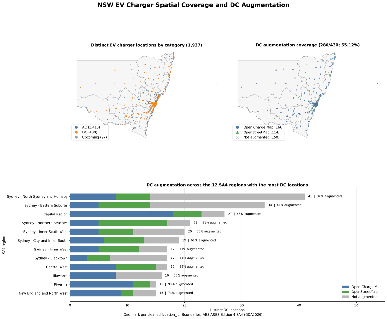
- Preserved all 1,956 source records across 1,937 distinct charging locations, with every record assigned to an SA4 region.
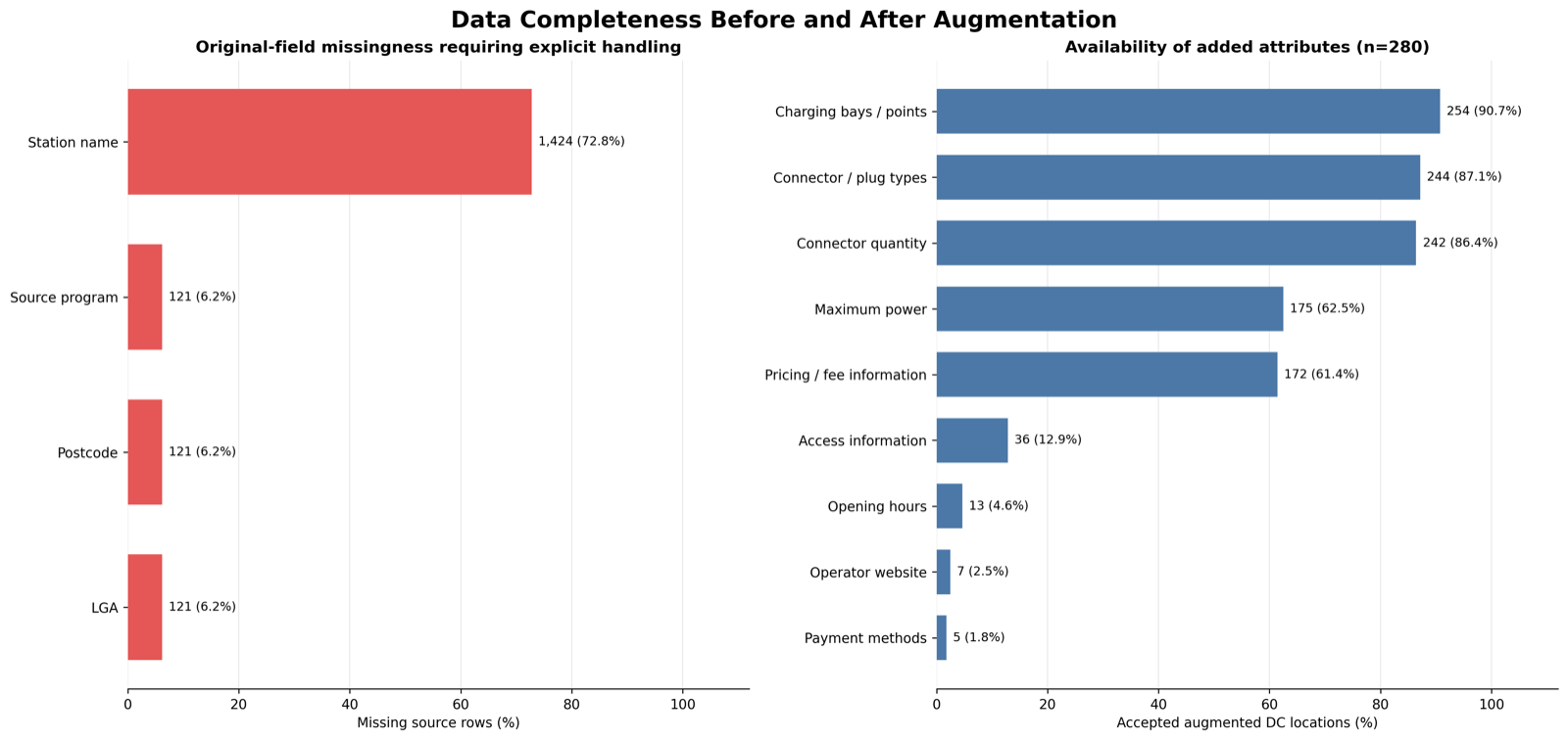
- Enriched 280 of 430 DC locations (65.12%): 166 through Open Charge Map and 114 through OpenStreetMap, with decision evidence retained.
- Produced a six-table spatial database, CSV and Parquet exports, and a saved validation report passing all 24 final checks.
These figures describe the saved 13 October 2026 run, not a live charging inventory. Sources describe different times, and accepted enrichment is not proof that every attribute is accurate or a charger is operating. The run retains 11 review decisions and 150 DC locations without accepted enrichment; those categories can overlap. The source coordinate system is a configurable assumption, and fresh API responses can change the results.